

Agenda, Oct 27
Bike Network Alternatives
The major item on the agenda on Tuesday was staff’s response to Council’s ask for lower cost alternatives to the planned bike network. The cost of the bike network is way more than originally estimated due to rampant construction cost inflation over the last few years and a lack of understanding around the actual scope and complexity of the project back in 2018. So Council has asked staff to develop some lower cost options and staff have brought forward adjustments for Council to consider in bundles. Council has already scrutinized the 2026 and 2027 projects and now staff have prepared options for the 2028 and 2029 projects.
The report landed directly at Regional Council without going through the normal committee process of Active Transportation Advisory Committee and the Transportation Standing Committee. This is important because there are opportunities for public engagement at both ATAC and TSC. Staff skipped the Committees due to time constraints related to budget deliberations. Basically, Tuesday was the staff deadline for budget items for the coming year!
Council asked some questions about the timeline and as it turned out, having this report ready for Tuesday was more of a “nice to have” rather than a mission-critical necessity. This is because all of the projects are part of 2028 and 2029 and not the upcoming 2027 fiscal year. Sending things to Committee doesn’t impact any actual project timelines. They only really show up in this year’s budget as a multi-year estimate of how much HRM will spend on capital and some potential planning and design costs. They’re not really a factor in the 2027 budget. The Halifax Cycling Coalition and others asked Council to send the report to Committees where public input and further review can happen and so Councillor Cleary put forward a motion to do just that. Council approved the referral to Committee 15-2 (Fillmore and Purdy voting no).
So what I was thinking would be a 2-3 hour debate (I had three potential amending motions ready to go) ended up being a 15 minute discussion. This will come back to Council in the future once the Committees have reviewed and provided recommendations.
Although this will return to Council in future, I wanted to provide a few initial thoughts on the three District 5 projects in the report. They’re in my district and what I have spent the most time looking at. I’m open to feedback on all three, this is just my initial take.
Woodside Ferry Terminal
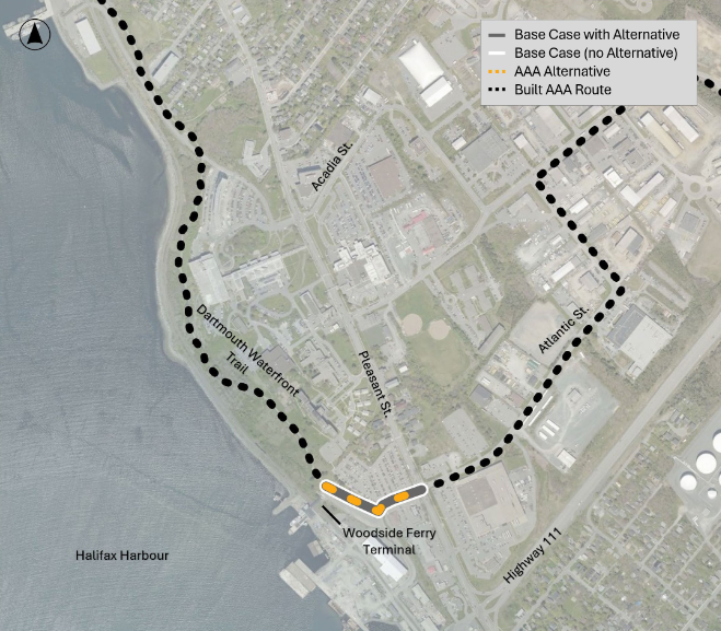
Over in Woodside, there is a small gap between the Harbour Trail’s current end at the Ferry Terminal loop and the start of the Mount Hope Greenway on the other side of Pleasant Street. The original plan was to replace the sidewalk along the Ferry Terminal loop and Atlantic Street with a multi-use pathway to link up to Mount Hope. A cheaper alternative would be to continue the multi-use path from the Trail to Atlantic Street, but then build a two-way bikeway on Atlantic using precast curbs (like what exists on Wyse Road) to connect to Mount Hope. This would save about $36,000.
This change actually looks like it has merit. Giving pedestrians and cyclists on Atlantic Street separate spaces eliminates potential conflict and would actually be cheaper to build, although the savings aren’t really significant in the grand scheme of things. As long as the intersection at Pleasant Street makes sense this seems very doable and a win-win.
Banook – Shubie
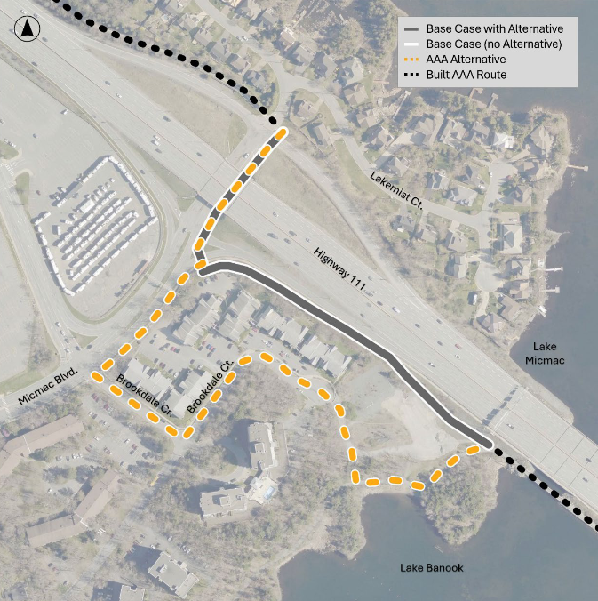
Over at Banook – Shubie it’s a bit of a different story. The Banook Greenway and Shubie Park are some of the most popular outdoor spaces in Dartmouth. They’re also, however, important transportation connections. If you’re looking to get to Dartmouth Crossing from anywhere on the east side of Lake Banook, you probably use these multiuse trails. There are also folks who detour through Shubie rather than ride with traffic on Braemar Drive/Waverley Road. Despite the significance of this route, there is a small gap that separates the two trails at the head of Lake Banook. What many folks currently do to bridge the gap is ride on the sidewalk that runs alongside the onramp for the Circumferential Highway and off-road on a very well-worn gravel path on the former YMCA property.
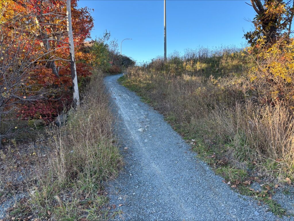
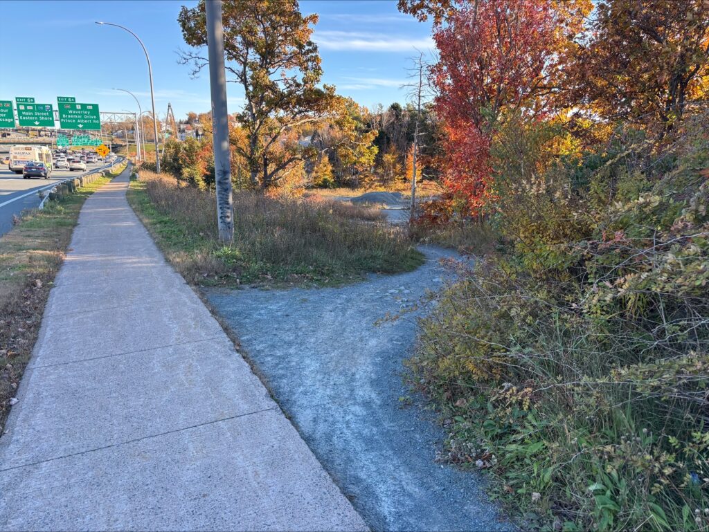
HRM’s current plan for this section is to upgrade the sidewalk to a multi-use trail. Basically, HRM plans to formalize how people are already travelling. This would create an unbroken stretch of multi-use trail from Banook all the way out through Shubie. Building this multiuse trail would require moving some highway street lights and building retaining walls and is estimated to cost $720,000. Rather than take on that costly work, staff have suggested that HRM could instead turn Brookdale Crescent into a local street bikeway. This would save an estimated $269,000.
I don’t think this particular alternative is worthwhile. The reason is a local street bikeway on Brookdale Crescent would be much less direct. I plotted the two routes out in HRM’s GIS Explore application and it gave me a total distance of 310 metres for the current plan versus 625 metres for the Brookdale Crescent alternative.
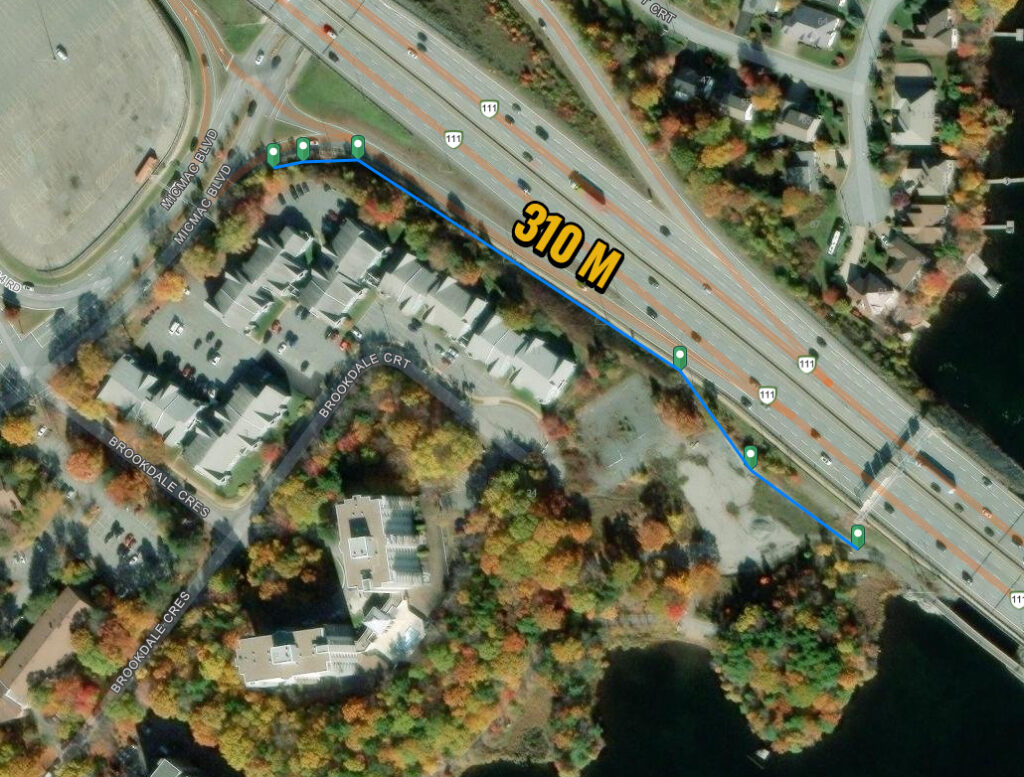
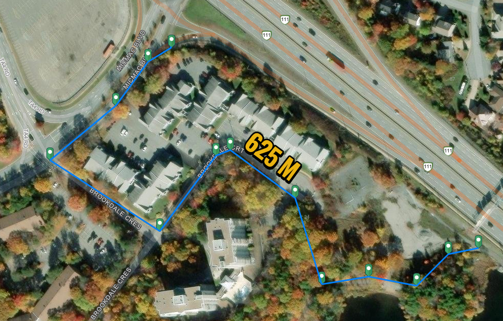
I think the reality is that if HRM goes with the Brookdale Crescent alternative, that well-worn gravel path on the side of the highway will still be busy because most people won’t use an indirect route that is more than double the distance.
I did discuss the Brookdale option with staff in some detail and they did point out that Micmac Boulevard will be getting a multi-use trail as part of the M District (Mic Mac Mall) development, meaning there could be a lot more demand for a connection at Brookdale Crescent in the future. That’s true, but that’s not the current reality and it doesn’t change that many folks are using the side of the highway right now because that’s the route that is the most direct. Even if we think about the future M District, and imagine someone trying to get from there to the bridge at Lake Banook, going alongside the highway would actually still be the shorter distance! The difference isn’t as significant, 455 m compared to 485 m, but Brookdale is still a longer trip when the M District is the starting point.
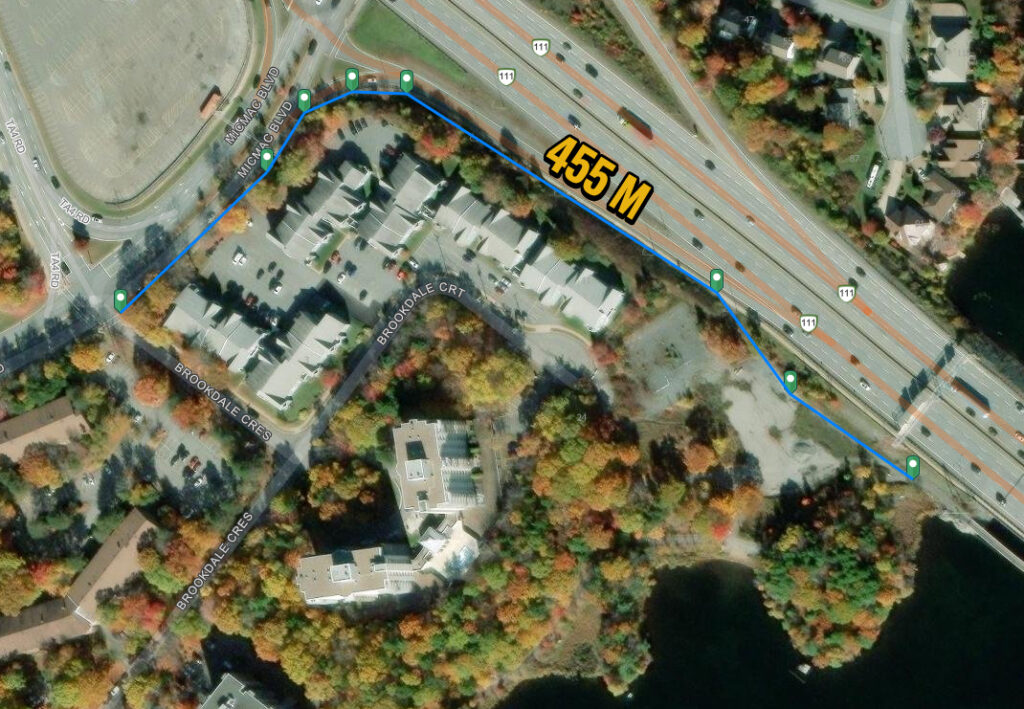
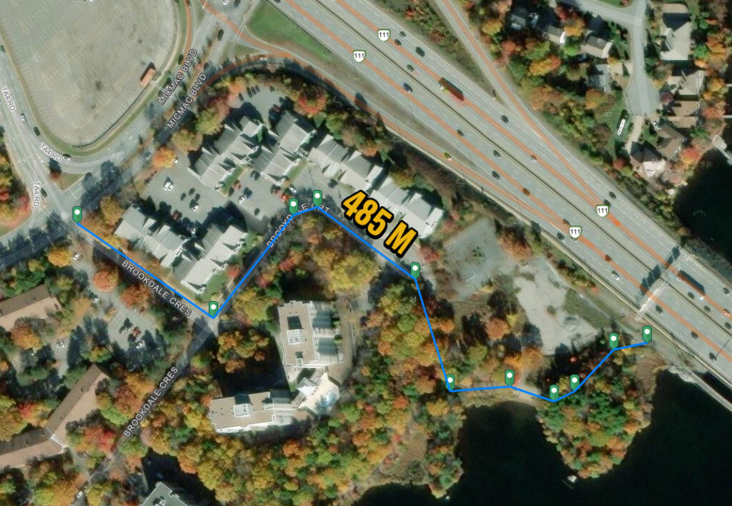
So even when M District is built out, the shortest route between A and B will still be a multiuse path alongside the highway. Brookdale will always be less direct. The only positive Brookdale has, besides being somewhat cheaper, is it’s more pleasant. It’s a quiet residential street rather than a loud highway edge. I don’t think that is enough of a positive though to build something that is measurably less useful and will likely not be well-used as a result. Brookdale looks good on a map. It would let HRM draw some lines and say there is a connection, but my bet is the actual on the ground reality is that most folks will just keep on riding alongside the highway.
HRM should stick with the $720,000 multiuse path option. The Brookdale alternative would be a penny-wise but pound-foolish switch and, barring new information, I’m very much not in support. If Council had debated this on Tuesday, I would have tried to amend the motion to stick with the current plan. Spending $451,000 to build something that won’t see much use versus spending $720,000 to build something that will… The goal here isn’t just to finish the bike network at the lowest cost. The goal is to build stuff that people will actually use!
Bridge – Alderney
Staff are suggesting some changes around the Dartmouth side of the Macdonald Bridge, specifically how the connection is made between the Bridge and the Harbour Trail down at Alderney Landing. This is a key section given that the Macdonald Bridge is one of the most important cycling routes in the city. It has also, however, been a very complicated section to design!
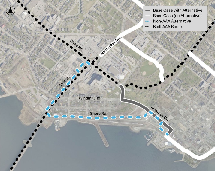
HRM originally planned to make the Bridge – Harbour Trail connection via a local street bikeway on Shore Road and Lyle Street and a multiuse trail along Alderney Drive. The major advantage with this route is the grade on Lyle is much more forgiving than the steep hill that climbs up to the intersection of Alderney/Wyse/Windmill (can I call this the AWW intersection?). Unfortunately, at the time, the Bridge Commission was less keen on this approach, which led staff to instead focus on options that would extend the Wyse Road bike lanes. Extending the Wyse lanes would be more direct, but the uphill portion would be a challenging climb for anyone not riding an e-bike. It’s steep!
The Wyse Road extension would also be many times more costly as Alderney coming up to the AWW intersection would need to be widened. Widening this section is not a simple project given the stone retaining wall and steep slope on the Common. With cost looming large in the bike network project, staff are suggesting going back to the original Shore Road/Lyle route. Shore Road/Lyle is estimated to cost $460,000 versus $5,183,000 for the Wyse Road extension. A $4,723,000 cost difference!
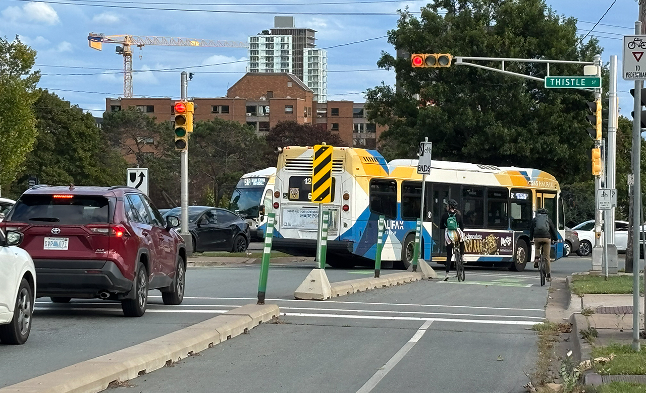
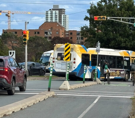
I’m way less certain as to what the best call is on this one. I brought it up at a neighbourhood association meeting this evening and three cyclists approached me after to say that they like riding Shore Road. I do worry though that putting this project through the lens of just the bike network is missing the forest for the trees. Widening Alderney from AWW to Geary wouldn’t just be for bike lanes it would also make space for dedicated bus lanes, creating the opportunity for bus only lanes all the way from Thistle Street, down to the Ferry Terminal, and around to the Sawmill River over by Prince Albert Road. This is a major transit route. There are 11 bus routes that travel on this section of road and they all get stuck here in rush hour traffic as they near the Bridge. The importance of transit here will only grow as HRM is planning for a bus rapid transit line from Bridge Terminal out Portland Street. The Wyse Road extension is much more expensive than Shore Road/Lyle, but we also get way more out of it than just bike lanes. It is really as much, if not more so, a transit project.
The staff report really didn’t consider the transit angle in a robust way, and my intent on Tuesday was to ask Council to approve a supplemental report seeking a more holistic assessment of this option. It’s way more expensive, but we also get much bigger improvements in terms of the overall transportation network and we shouldn’t wait for bus rapid transit to be thinking about this. We have buses in the here and now that get stuck in traffic along here every work day.
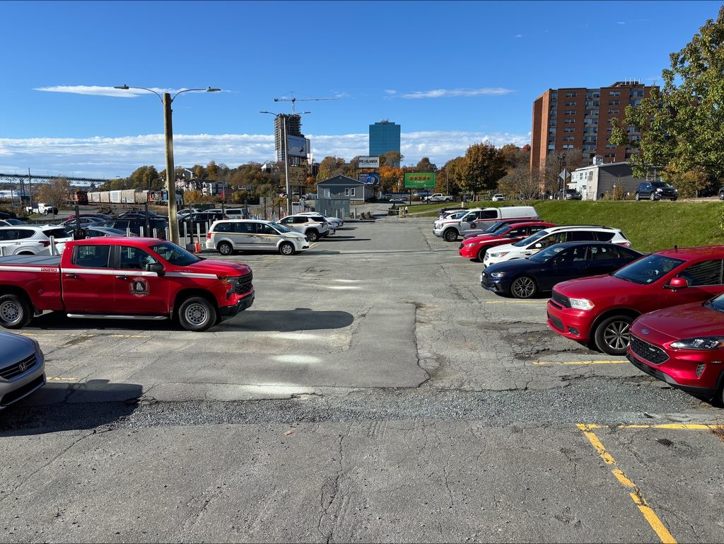
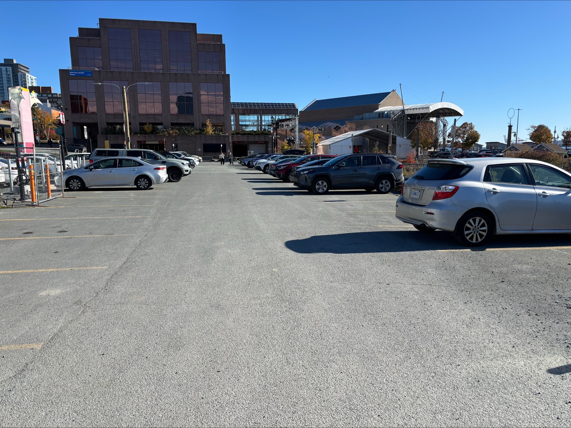
There is one other thing to note about the Shore Road/Lyle alternative (or reversion given the project history here). Staff are suggesting that the connection to the Harbour Trail be made through the parking lots between Alderney Drive and the train tracks. The report notes that this section wouldn’t be built to an All Ages and Abilities standard. Basically bikes would just travel through the parking lot. I don’t think this is acceptable.
Anyone in Dartmouth who has parked in the public parking section in this lot knows that it’s not a standard parking lot width. The drive aisle are narrower than normal, which makes parking somewhat challenging and, crucially, impacts sight lines and maneuverability. Drivers typically go slow through here as a result (a plus), but it’s also a bit of a tricky spot. The likely point of conflict here would be someone backing into a cyclists travelling down the parking lot aisle.
I’m not convinced that HRM has to give up the AAA standard. My hunch is that if HRM was willing to take out one row of parking, we would have enough room to create a protected space for bikes and pedestrians. It would be better to make this connection in the HRM fleet vehicle lot, because it’s nowhere near as busy as the higher turnover public parking. I made a point of visiting the parking lot three times over the last few days and at 3:00 PM on Monday, there were 17 vehicles on the fleet side and approximately 23 empty parking spaces. I returned at 8:00 PM to see if a whole bunch of vehicles had come back at the end of the day and there were only 14 HRM vehicles in the lot for overnight parking. I counted again on Tuesday morning on my way to the ferry and at 9:45 AM there were 25 vehicles in the fleet lot, but 10 of them appeared to be personal vehicles (presumably HRM employees). A number of the fleet vehicles that are stationed in the lot on an ongoing basis belong to fire, which will be relocating to the new fire headquarters in Bedford and, presumably, taking their fleet vehicles with them. In short, it appears HRM has space here that could be repurposed. Usage in the fleet vehicle lot seems to be under 50%. If Council had debated this on Tuesday, I would have tried to amend the motion to direct that separated space be created by repurposing parking.
Those are my impressions of what’s proposed. A good idea, a bad idea, and a strong maybe. If you have any opinions on these routes please don’t hesitate to reach out. Council will be looking at everything in detail in the future after the Committees have had a chance to consider the proposed changes.
Other:
- Referred a number of staff reports to future budget deliberations including reports dealing with the fire department, Lucasville micro-transit project, in-house operations for household hazardous waste, staffing in Winter Works, and on having a dedicated staffer to work on defence infrastructure planning with the military
- Received a presentation from HRCE on last year’s supplemental funding program
- Approved transit’s plan to recoup lower than budgeted fare revenues stemming from Council’s decision to delay the planned fare increase to align with the implementation of tap-to-pay fare payment
- Reallocated funding in Public Works to purchase new equipment for the HRM Sign Shop
- Reallocated funding amongst streetscaping projects to cover the 2027/2028 program from previously unspent project funds
- Endorsed the Halifax Partnership’s approach to developing a new economic strategy for HRM
- Approved the Mayor’s motion for a report that would look at making it easier for residents to close local streets for Halloween